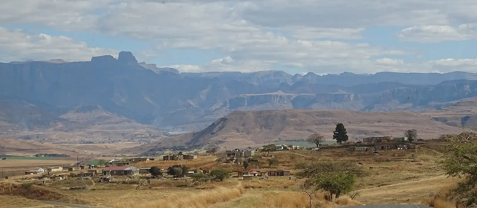
Drakensberg mountains: choose the region before the hotel
The Drakensberg forms a mountain frontier along eastern South Africa and Lesotho. This guide focuses on the main South Africa visitor regions and their hiking approaches. You may see the name misspelled “Drakensburg”; it refers to the same mountain range, not a separate destination.
The northern, central and southern regions are separated by long road journeys. Nearby-looking valleys can have different access roads, and there is no convenient tourist road running along every trailhead below the escarpment. Choose your main walking objective before deciding where to sleep.
| Region | Useful bases | Main reasons to choose it | A sensible first stay |
|---|---|---|---|
| Northern Berg | Royal Natal valley, Bergville area, Witsieshoek | Amphitheatre views, Tugela Gorge and Sentinel route | 3-4 nights |
| Central Berg | Cathedral Peak/Didima and Champagne Valley | Forest gorges, waterfall circuits and hotel-based walks | 3-4 nights |
| Southern Berg | Underberg, Himeville and Sani foothills | Giant’s Cup, valley walks and a separate Sani Pass outing | 3-5 nights |
Royal Natal’s valley approach and Witsieshoek’s high approach need particular care. They give different views of the same escarpment but are not connected by a drive through the mountain. A Royal Natal hotel does not automatically make the Sentinel trailhead a short morning transfer.
Compare trails by distance, time and ascent
Use the named start point and endpoint when comparing trails. Distances and ascent totals are approximate route measurements; detours, a different turnaround and GPS processing can change them. Times below include practical walking allowances, with longer needed for slow groups, photographs or difficult ground.
| Trail and version | Start point | Total distance | Hiking time | Approximate elevation gain | Difficulty and key constraint |
|---|---|---|---|---|---|
| Sentinel Chain Ladders to Tugela Falls plateau | Sentinel Peak Car Park via Witsieshoek | 12.4 km (7.7 miles), return | About 6 hours | About 470-490 m (1,540-1,610 ft) | Exposed ladders and high plateau |
| Tugela Gorge, extended valley route | Gorge trailhead, Royal Natal side | 13.8 km (8.6 miles), return | 4-6 hours | 626 m (2,054 ft), route-track total | Long valley outing; rocks and water can slow the finish |
| Rainbow Gorge, longer hotel-start route | Cathedral Peak Hotel | 11.1 km (6.9 miles), return | 4.5-5 hours | 315 m (1,033 ft), route-track total | Forest and gorge terrain, slippery after rain |
| Sterkspruit and Nandi Falls circuit | Monks Cowl entrance | About 8-8.3 km (5 miles) | 3-4 hours | About 290-300 m (950-985 ft) | Moderate waterfall circuit with climbs and crossings |
| Giant’s Cup, full trail | Sani Pass road trailhead to Bushman’s Nek | 59.3 km (36.8 miles), one way | 5 hiking days | Not given as one figure; later stages run about 12 km a day | Multi-day logistics, hut bookings and end transfer |
Elevation gain means climbing along the route, not the height of the mountain or waterfall. Witsieshoek publishes 472 m of ascent for the Sentinel route, while the car park and crest heights below differ by just under 490 m, so the table gives the range. Do not combine one route’s distance with another’s highest point to judge difficulty.
Sentinel and the top of Tugela Falls
The Sentinel route is the famous high approach to the Amphitheatre plateau. It starts at the Sentinel Peak Car Park, around 2,500 m (8,202 ft), and reaches the Chain Ladders before continuing onto the escarpment. The published crest height is around 2,987 m (9,800 ft).
The attraction is access to the high plateau without a multi-day ascent from the valley. That does not make the route casual: the ladders are exposed, the ground above them can be confusing in mist, and descent needs time. A guide is a sensible choice if you are inexperienced with route-finding or uncomfortable with heights.
Allow about six hours for the full 12.4 km (7.7-mile) return outing. Start early enough to descend before afternoon storms build in summer. Witsieshoek’s hiking information covers the route and the last access section, which is different from the ordinary road to the lodge.
As of November 2026, the final 7 km (4 miles) from Witsieshoek to the car park requires a 4x4, with a lodge shuttle offered as an alternative. That access transfer sits outside the walking time. A low-clearance rental car should not be treated as suitable simply because it reached the lodge.
Tugela Gorge: below the Amphitheatre
Tugela Gorge approaches the mountain wall from the Royal Natal side. It is the better choice if you want a valley walk with views upward rather than the exposed high-plateau route. The trail does not reach the top of Tugela Falls, and its small gorge ladders are not the Sentinel Chain Ladders.
Allow a substantial part of the day. The extended route in the table is approximately 13.8 km (8.6 miles), with four to six hours of walking before allowing for an unusually slow final section. Other published versions turn around earlier or use a different starting point, explaining why shorter and longer totals appear elsewhere.
The upper gorge is more affected by water and rocks than the open approach. High river levels can make a planned turnaround sensible before the most confined section. A successful outing does not require pushing into unsafe water just to match a distance recorded by someone else.
The views are usually easier to appreciate when cloud does not cover the wall. Clear, dry days in the shoulder seasons make a useful target. Summer rain can strengthen waterfalls, while also increasing the need for a conservative river and storm plan.
Rainbow Gorge and the Monks Cowl waterfalls
Rainbow Gorge provides a central-Berg alternative to the high escarpment. The longer hotel-start version in the table runs roughly 11.1 km (6.9 miles), with about 315 m (1,033 ft) of ascent. Give it 4.5-5 hours for a comfortable outing rather than importing the shorter Didima-start distance.
The route moves from open ground into forest and rocky gorge terrain. The practical attraction is the change of landscape within one walk. Wet rocks, stream levels and the group’s confidence determine how far into the gorge is appropriate on the day.
In Champagne Valley, the combined Sterkspruit and Nandi Falls circuit begins at the Monks Cowl entrance. It is about 8 km (5 miles) with roughly 290 m of climbing and takes three to four hours. The direct Sterkspruit viewpoint walk is a shorter choice, but it is not the same itinerary as completing both waterfalls.
Choose these routes when you want a full walking day without committing to the Sentinel ladders. They still involve climbs and uneven surfaces; “lower Berg” does not mean paved or universally accessible. A hotel garden walk may be the better alternative for a group needing a gentler day.
Giant’s Cup: a multi-day southern route
The Giant’s Cup Trail links the Sani Pass road area with Bushman’s Nek over 59.3 km (36.8 miles). The standard full route takes five hiking days with a hut at the end of each stage; days three to five cover about 12 km, 11.8 km and 12.3 km. It is a through-hike rather than a succession of day walks returning to one hotel.
Hut reservations, food, carrying capacity and transport at both ends need to be settled before you start. A support or guiding arrangement can reduce some of that logistical burden, but does not remove the need to walk the stages. Choose it because you want several consecutive days on foot, not simply because its daily distances appear moderate.
For a shorter southern-Berg stay, use a base near Underberg or the Sani foothills and select day walks. The Sani Pass drive is a separate cross-border outing rather than part of every local hike. It deserves its own transport and weather decision instead of being appended to the end of a long walking day.
Amphitheatre, Tugela Falls and the World Heritage listing
The Amphitheatre is a basalt wall approximately 5 km (3 miles) wide, with roughly 1,000 m (3,281 ft) of relief above the valley in the commonly used tourism description. Its rim rises above 3,000 m (9,843 ft) above sea level. Relief and summit elevation measure different things, which is why a single “height” can be misleading.
Tugela Falls has a conventionally stated total drop of 948 m (3,110 ft) over five drops. Its water volume varies strongly with rain and season. The height does not mean you will see a continuous powerful waterfall on every visit, and competing world-height rankings are unnecessary for planning the walk.
The UNESCO-listed Maloti-Drakensberg Park is a mixed cultural and natural site. The original South African inscription dates to 2000, with the 2013 extension including Lesotho’s Sehlabathebe National Park. The combined property covers 249,313 hectares, about 616,000 acres.
San rock art is part of that heritage, alongside the mountain ecology and scenery. A guided rock-art outing offers a different way to understand the region, especially on a day when a high route is unsuitable. Use authorized visits to the relevant shelter rather than treating paintings as something to search for independently.
Driving from Durban and Johannesburg
There is no single drive time “to the Drakensberg.” The route below ends at a named base, with time for mountain access still separate. Rental-car travelers should leave additional room for fuel, food, traffic and slow final roads.
| Named destination | From Durban | From Johannesburg | Access detail |
|---|---|---|---|
| Witsieshoek Mountain Lodge | About 370 km (230 miles), 4 hours | About 345 km (214 miles), 4 hours | Approach through Phuthaditjhaba |
| Cathedral Peak Hotel | About 250 km (155 miles), 2.5 hours | About 400 km (249 miles), 4.5 hours | Final approach is winding and can be slow |
| Sani Lodge, southern Berg | From King Shaka airport: about 3 hours | From OR Tambo airport: about 7 hours | Via Underberg; lodge is about 20 km (12 miles) beyond town |
The airport origins in the Sani row differ from the city origins in the other rows. That distinction matters when joining a domestic flight to a road transfer. Sani Lodge also gives roughly 3.5 hours for the easier road journey from the northern or central Berg to its southern base.
Do not accept a navigation route from Royal Natal through the mountain to Witsieshoek: that drive does not exist. The correct Sentinel-side approach is through Phuthaditjhaba. For an arrival followed by a hike, spend the first night near the correct trailhead rather than attempting the full drive and a major walk in one day.
Where to stay by region and budget
Budget stays work best when they give you kitchen access or straightforward hiking accommodation near your chosen region. Mid-range lodges and country hotels add comfort without necessarily including every meal or activity. A higher-end resort can be worthwhile when some travelers want walks while others prefer facilities at the property.
- Amphitheatre Backpackers Lodge - Northern Berg/Bergville area - Budget. It offers camping and private-room options as a lower-cost regional base.
- Cathedral Peak Self-Catering & Backpackers - Cathedral Peak - Budget. Its accommodation gives access to walks in the Cathedral Peak area.
- Sani Lodge & Cottages - Southern Berg/Sani foothills - Budget. The property combines accommodation with a local hiking and touring base near Underberg.
- Witsieshoek Mountain Lodge - Sentinel/Phuthaditjhaba approach - Mid-range. Its location serves the high Sentinel trailhead rather than the Royal Natal valley approach.
- The Nest Hotel - Champagne Valley - Mid-range. The country hotel provides a central-Berg base with several room styles and mountain views.
- Cathedral Peak Hotel - Cathedral Peak/Didima - Luxury. Its setting supports a stay organized around the hotel’s network of walks and facilities.
- The Cavern - Northern Berg - Luxury. The resort offers garden and forest-facing accommodation alongside guided walking opportunities.
These are relative accommodation tiers, not a substitute for comparing your travel dates and room categories. A full-board resort and a self-catering room can have similar-looking room prices but different total meal costs. The more important first filter is the driving distance to the actual trailhead.
When to go, including snow months
April-May often suits hiking because summer’s heavy rain is easing and winter’s deepest cold has not yet arrived. September-October can also work well, with returning warmth but variable spring conditions. Neither period removes the need for a mountain weather decision on the morning of the walk.
December-February brings greener valleys, fuller streams and afternoon thunderstorms. Start exposed routes early and leave capacity to change plans. The South Africa summer guide explains why a beach-and-Berg trip needs a different weather strategy from a Cape Town vacation.
June-August is the main window for possible snow, particularly on higher ground after cold fronts. Snow is not guaranteed at your hotel, and a white summit can coexist with dry grass in the valley. Ice, low temperatures and road restrictions may make a lower walk the better option.
Choose the season for your main activity. Hiking flexibility is more useful than booking a winter trip on the assumption of dependable snow. For a broader route, compare the mountains with the best places to visit in South Africa.
Hiking costs and practical safety
Budget separately for accommodation, reserve access, any trail-specific fees, guiding and a trailhead shuttle. Self-catering lowers meal costs, while a guide or 4x4 transfer can be the most useful additional spend on an exposed route. Do not assume a hotel booking includes every permit or the journey to the start.
For the Sentinel route, the adult conservation fee is R90 and the day-hiking fee R145 as of November 2026, within the published March 2026-February 2027 tariff period. The return lodge-to-car-park shuttle is R320 per person. Together those named items total R555 for an adult using the shuttle, before guiding, food or accommodation. A hiker with suitable trailhead transport has a different total, which is why the shuttle should be visible in the budget rather than hidden inside an assumed access fee.
As of November 2026, official travel advice recommends care with outdoor activities and isolated areas. Carry weatherproof and warm layers, food, navigation and enough water for the full route; use the mountain register where provided. Check current trail, road and mountain-weather restrictions before setting off, and turn around early if conditions deteriorate.
For a three-night first trip, plan one shorter introduction, one main hike and one flexible lower-level day around the arrival and departure times. Combine a central or southern stay with the Durban hotel areas if the coast is next. A Johannesburg stay can connect well with the northern approach, provided the road transfer receives its own time.
Frequently asked questions
Is Drakensburg the same place as Drakensberg?
Yes, Drakensburg is a common misspelling of Drakensberg. Use Drakensberg when searching for the mountains, reserves and accommodation.
What is the best Drakensberg mountain hike for a first trip?
Choose a route that matches your fitness and comfort with heights, rather than starting with the most famous summit. Rainbow Gorge and the lower waterfall routes offer alternatives to the exposed Sentinel Chain Ladders.
Does the Tugela Gorge hike reach the top of Tugela Falls?
No, it approaches the gorge below the Amphitheatre from the Royal Natal side. The high route to the top uses the separate Sentinel car park approach via Witsieshoek.
When does it snow in the Drakensberg mountains?
June-August is the main winter window for possible snow, especially on higher ground after cold fronts. Snow is variable, and ice or closed access roads can make hiking less practical rather than improving the trip.
How far is the Drakensberg from Durban or Johannesburg?
It depends on the region and trailhead. Witsieshoek gives approximately four hours from either city, while Cathedral Peak gives about 2.5 hours from Durban and 4.5 hours from Johannesburg before extra allowances.
Can beginners hike in the Drakensberg?
Yes, lower garden, valley and waterfall walks provide options for less experienced visitors. The high escarpment, exposed ladders and multi-day routes require a different level of preparation and should not be chosen simply because they appear in the same guide.
Sources
- UNESCO - Maloti-Drakensberg Park whc.unesco.org
- South African Tourism - Amphitheatre dimensions southafrica.net
- Witsieshoek - hiking routes and access witsieshoek.co.za
- Witsieshoek - drive times and correct approach witsieshoek.co.za
- Witsieshoek - accommodation witsieshoek.co.za
- Royal Natal route records and ascent comparisons storm.ski
- Rainbow Gorge longer route - recorded distance and ascent outdooractive.com
- Cathedral Peak Hotel - walks and hikes cathedralpeak.co.za
- Nandi's Falls Hike - SA-Venues sa-venues.com
- Sterkspruit Falls - Nandi's Falls loop from Monk's Cowl - komoot komoot.com
- The Nest - waterfall hiking routes thenest.co.za
- Giant’s Cup Trail - stage distances sahikes.com
- Giant's Cup Hiking Trail - SA-Venues sa-venues.com
- Cathedral Peak Hotel - driving directions cathedralpeak.co.za
- Sani Lodge - travel times sanilodge.co.za
- Sani Lodge & Cottages sanilodge.co.za
- South African Tourism - winter and snow southafrica.net
- Amphitheatre Backpackers - accommodation amphibackpackers.com
- Cathedral Peak Self-Catering & Backpackers cathedralpeakbackpackers.co.za
- The Nest Hotel - accommodation thenest.co.za
- The Cavern - accommodation cavern.co.za
- FCDO - South Africa outdoor and travel safety gov.uk